| General Details |
|---|
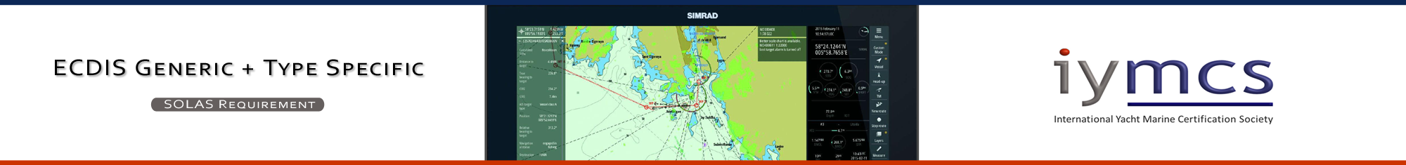
| Course & Certification:
ID: 6.1.25 Description: ECDIS Generic + Type Specific Certification type: Certificate of Proficiency ISO 9001:2015 compliance course & certification. |
| Course Length:
A total of 38 hours consisting of: Pre-Course study = 2 hours; |
| Capacity of certification:
For Master of vessels less than 500GT, Officer of the Watch of vessels less than 1600GT, carrying no more than 12 passengers. |
| Recognitions & approvals:
STCW 1978/2010 amend. A-VII Part 4-1 Principles to be observed in keeping a navigation watch. |
| Reference Standards:
IMO Model Course ref: 1.27 |
| Examining body:
Global Institute for Maritime Education and Training, 900682 Constanta, Romania. |
| Certification Revalidation:
Required every 5 years with the undertaking of an ECDIS refresher course on a 2-station simulator |
| Sea-time requirements:
90 days Onboard Service and 30 days actual sea-time. |
| Certification issuing requirements:
Seafarers Medical Certificate |
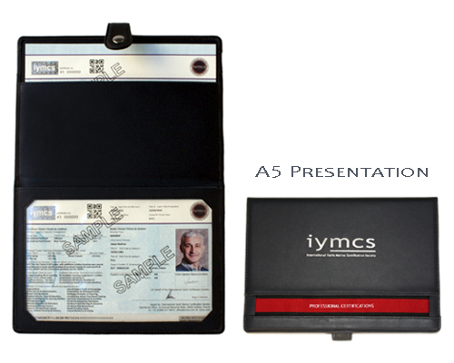
The custom-designed Iymcs presentation folder type certification is stylish and practical.
The presentation folder outer is made of real leather with a sythentic interior that is resistant to water and protects the certificates.
It is A5 in size, it can hold up to four Certificates, and is an ideal size to be kept in a crew document case or with the boat's documents.
The Iymcs Certificates are printed to ISO 9001:2015 standards, are dual-language and feature extensive security features
to security level 3 (Government passports & national Iidentification documents are security levels 1 & 2) and can be used as a personal ID in daily situations.
(Nb. It cannot be used instead of a passport/national identity card).
The Iymcs ECDIS Generic + Type Specific course is the IMO model course ref. 1.27, concerns the operation of ECDIS for watch-keeping at an operational level for Master of vessels less than 500GT, Officer of the Watch of vessels less than 1600GT, carrying no more than 12 passengers.
The course focuses upon: Passage & Route Planning, Passage & Route Monitoring, Collision Avoidance Between Vessels, Open-Seas Navigation, Near-Coastal Navigation, Confined Waters Navigation. It is most suitable for deck/bridge watch-keepers on super-yachts, classic sail vessels and small commercial workboats.
An IMO type approved 2-station (instructor+student) consisting of Radar, ECDIS with visual scenario reality, is used. This enables you to practice the coordination the operation of ECDIS together with Radar, as well as visually what you are seeing in the scenario. The scenarios are created by the instructor using worldwide ports, harbours, narrow channels of all types and sizes with varying coastal features. The sea & meteorogical conditions are varied, vessel traffic is increased/decreased using different types of vessels.
A continous assessment is made of how you perform the tasks on the simulator, which is graded according to the operation standard you have achieved. Additionally, there is a written ECDIS Exam to undertake and pass to qualify.
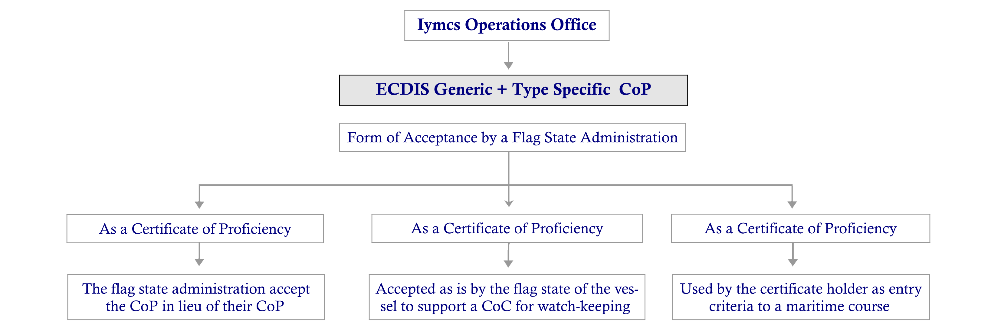
Certification Structure:
The certification issued is an Iymcs Certificate of Proficiency (CoP), it needs to be presented to the Flag Administration of the vessel you intend
to work-on, or are working on, for their independent assessment, acceptance on a case-by-case basis.
Our Society, the 'International Yacht Marine Certification Society" (Iymcs) operates its entire operations under a Quality Management System
(QMS) that is in compliance with the International Standards Organisation (ISO) 9001:2015 amended. Part of this compliance involves full auditing procedures.
This is an important reference and enables us to gain recognitions from maritime administrations and marine industry bodies alike.
The QMS together with the ISO, ensures that Iymcs and its Members operate to the highest standards possible. All our courses, and more importantly the
Certifications that we issue, are under ISO 9001:2015.
This practice is most unusual to see for such courses and certifications. It ensures a uniform and consistent quality standard throughout the Society's operations.
| Scandinavia 1.100,-EUR | Northern Europe 1.000,-EUR | United Kingdom 740,-GBP |
| Southern Europe 865,-EUR | Middle East 970,-USD | North America 890,-USD |
| Prices exclude: course books,certification costs,personal traveling costs,course food and course accommodation. | ||
( IMO model course 1.27. Vers. 1.2. ) Click-on '+' to see Syllabus
History of the development of ECDIS. SOLAS significance. Screen & keyboard characteristics. Navigation bridge integration. Approved ECDIS Software. ECDIS Terminologies. UKHO ECDIS 5012 publication. ISM operating guidelines. IRPCS review concerning use of ECDIS
1.1 Course introduction & familiarization plan. 1.2 Purpose of ECDIS. 1.3 Value to navigation. 1.4 Correct & incorrect use. 1.5 Work station start, stop & layout. 1.6 Vessel position. 1.7 Position source. 1.8 Basic navigation. 1.9 Heading & drift vectors. 1.10 Understanding chart data. 1.11 Chart quality & accuracy. 1.12 Chart organization.
2.1 Sensors. 2.2 Ports & data feeds. 2.3 Chart selection. 2.4 Chart information. 2.5 Changing the settings. 2.6 Chart scaling. 2.7 Information layers. 2.8 System & position alarms. 2.9 Depth & contour alarms.
3.1 Vessel manoeuvring characteristics. 3.2 Route planning by table. 3.3 Route planning by chart. 3.4 Track limits. 3.5 Checking plan for safety. 3.6 Embedded tide, current and climate almanac. 3.7 Route schedule. 3.8 User charts in route planning
4.1 ARPA tracked target overlay. 4.2 AIS functions. 4.3 Radar overlay (RIB) functions. 4.4 Procuring & installing chart data. 4.5 Installing chart corrections. 4.6 System reset & backup. 4.7 Archiving with ECDIS data management utility. 4.8 Data logging and logbook. 4.9 Playback.
5.1 Col.Regs application using ECDIS. 5.2 SOLAS aspects concerning ECDIS. 5.3 IMO approval of equipment & installations. 5.4 IMO carriage requirements. 5.5 STCW code aspects concerning ECDIS. 5.6 Flag State implementation of ECDIS & the carriage of. 5.7 IMO training guidance. 5.8 ISM requirements of ship owners & operators.
6.1 The bridge functions incorporating ECDIS. 6.2 Sample bridge instructions addressing ECDIS. 6.3 Definition of safe and practical navigation with ECDIS. 6.4 Evolving concepts of e-navigation with regards to ECDIS.
SMCP phrases & terminologies. Target reporting priorities. Time intervals of target reports. Recommended actions to take for collision avoidance.
Operating system seizures. Scanner issues. No data received from interfacing units. Power supply issues.
ENC data error reporting. Software glitches reporting. Uncharted obstructions, features & objects. Interfacing information data error.
Assignment 1:
ECDIS start-stop, screen layout options, vessel position, position source, chart selection, chart information.
Assignment 2:
Radar ARPA tracked target overlay, AIS functions, Radar overlay (RIB) functions.
Assignment 3:
Basic navigation, heading & drift vectors, understanding chart data, changing the settings, chart scaling, information layers.
Assignment 4:
Route planning by chart, track limits, checking plan for safety, procuring & installing chart data, installing chart corrections.
Assignment 5:
Open sea basic integrated navigation co-ordinating ECDIS with Radar together with visual referencing and situation awareness.
Assignment 6:
Near-coastal navigation adjusting chart settings, electronic bearings position lines positioning, radar overlay and adjustment of PPI.
Assignment 7:
Near-coastal and confined waters navigation, visual referencing to AtonNs & charted features and objects, navigation alarms & route scheduling.
Assignment 8:
Confined waters (pilotage) advanced integrated navigation with ECDIS.
Assignment 9:
Multiple-Vessel Collision Avoidance in a TSS or Narrow Channel using ECDIS, Radar and visual.